
Resultados de la búsqueda
Para más opciones de búsqueda, vea Ayuda:Búsqueda.
Quizás quisiste decir: topographic mars
Si consideras que este artículo debería existir, conoces nuestros pilares, dispones de fuentes fiables y sabes indicarlas como referencias, puedes crearlo, opcionalmente usando nuestro asistente.
 2007 en Wayback Machine. (en alemán) Natural tourism (birdwatching) in NE Poland Topographical maps 1:50 000 Datos: Q815834 Multimedia: Masuria / Q815834…7 kB (757 palabras) - 19:56 20 oct 2023
 Recreation Element of the General Plan, June, 1984 U.S. Geological Survey, Topographical Map, San Quentin 7.5 Minute Quadrangle, revised 1980 Ciudad de San Rafael…4 kB (373 palabras) - 17:03 9 ene 2024
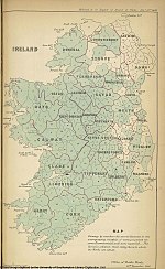 sobre Baronías de Irlanda. Itineraries for Irish Topographical Botany includes large JPGs of the county maps from Robert Lloyd Praeger's copy of Philips'…6 kB (576 palabras) - 00:11 1 ago 2023
 Pocket Plan of the City of New York». Old Maps. Consultado el 9 de julio de 2018. Colton, J.H. (1836). «Topographical map of the city and county of New-York…7 kB (744 palabras) - 04:48 20 mar 2024
 Creative Commons Atribución-CompartirIgual 4.0 Internacional. MSR Maps - USGS topographical map and aerial photo Datos: Q581841 Multimedia: Lake Coeur d'Alene…6 kB (631 palabras) - 10:54 14 oct 2019
 Consultado el 13 de noviembre de 2015. Lawrence Richardson, A new topographical dictionary of ancient Rome, 1992, p.67. Alberto Manodori (1989). «RIONE…6 kB (591 palabras) - 17:11 9 ene 2024
 Thomas A history of the county of Surrey; comprising every object of topographical, geographical or historic interest by Thomas Allen illustrated with…9 kB (1097 palabras) - 05:08 31 ene 2024
 camino es anterior a la partición de Irlanda en 1921. Se menciona en A Topographical Dictionary of Ireland (1837) de Samuel Lewis, que describe la parroquia…12 kB (1350 palabras) - 13:52 24 may 2023
- Journal 10 (3): 155-173. Kalner, David (1941). «The Development of the Topographical Maping of Palestine / התפתחות המפות הטופוגראפיות של ארץ ישראל». Bulletin…40 kB (2309 palabras) - 11:43 26 feb 2024
- Platner, Samuel Ball; Ashby, Thomas (1929). Humphrey Milford, ed. A topographical Dictionary of Ancient Rome (en inglés). Londres: Oxford University Press…13 kB (1459 palabras) - 12:08 28 dic 2023
- Names and Their Histories: A Handbook of Historical Geography and Topographical Nomenclature (2nd ed.). London: Rivingtons. Wikimedia Commons alberga…9 kB (1084 palabras) - 22:10 3 ene 2024
 Gerhold, Dorian, London Bridge and its Houses, c.1209-1761, London Topographical Society, 2019, ISBN 978-17-89257-51-9; 2nd edition, Oxbow Books, 2021…19 kB (2470 palabras) - 22:52 14 abr 2024
 Mena-Segovia, Juan; Bolam, J. Paul; Martinez-Gonzalez, Cristina (2011). «Topographical Organization of the Pedunculopontine Nucleus». Frontiers in Neuroanatomy…8 kB (800 palabras) - 22:42 6 oct 2023
- Innes, J.H. (1902). New Amsterdam and Its People: Studies, Social and Topographical, of the Town Under Dutch and Early English Rule. Empire State historical…12 kB (1398 palabras) - 11:47 9 sep 2023
 & Company, 1878 pp.xix-xx, xxxi. Report of Captain A. A. Humphreys, Topographical Engineers, Upon the progress of the Pacific Railroad Expeditions and…10 kB (1299 palabras) - 17:52 14 nov 2023
 Names and their histories; a handbook of historical geography and topographical nomenclature (en inglés). Detroit: Gale Research Co. p. 420. Wikipedia…121 kB (11 839 palabras) - 20:28 1 abr 2024
 1-55849-201-1 Lost Boston (1999), Mariner Books, ISBN 0-395-96610-8 Boston: A Topographical History, Tercera edición ampliada (2000), Belknap Press, ISBN 0-674-00268-7…141 kB (15 035 palabras) - 07:57 13 abr 2024
 ISBN 0-86381-957-5. Chalmers, George (1887). Caledonia : or, a historical and topographical account of North Britain, from the most ancient to the present times…47 kB (5838 palabras) - 18:45 13 feb 2024
 ocurrió en 1859, cuando el topógrafo William F. Raynolds, del Corps of Topographical Engineers al servicio del ejército estadounidense, encabezó junto con…155 kB (17 269 palabras) - 21:18 11 abr 2024
 page 718. “Welcome to Jay County” web site. The Indiana gazetteer: or, topographical dictionary of the state of Indiana. E. Chamberlain. 1850. p. 247. Richard…43 kB (5554 palabras) - 19:07 8 oct 2023


